Written by Jennie Fiddes
When walking or driving along the lakeshore of Toronto, Lake Ontario seems to spread out as far as the eye can see. Although it is the smallest of the Great Lakes, it has been enormously influential in our past and continues to impact our present. During the summer, we can often see boats coming into the harbor and pedestrians strolling along the lakeshore. Yet few people are aware of how integral the lake has been to the history of Toronto, beginning with its very formation. The Lake has been a source of food, a source of transportation and a source of conflict for millennia.
Lake Ontario: Early Geology
For thousands of years, most of Ontario was covered in ice. The Great Lakes were created by the passage of these glaciers. When glaciers move, they can drastically alter the land around them, creating heaps of earth in front of them and trailing debris behind them. They also pick up and incorporate material from the ground as they pass, becoming giant blocks of gritty ice that scour all surfaces. As they melt, this load of large rocks, pebbles, sand, clay and silt drop out of the ice to cover the ground, creating a layer know as “glacial till” as well as leaving behind the natural landscape we see today.
These glaciers also captured an enormous quantity of water in the form of ice. The volume of water was so significant that the earth’s crust sank beneath weight of the glaciers. After they melted, the earth began to rebound and continues to do so today, at a slow pace of a few centimeters every hundred years.
As the ice age ended and the vast walls of ice retreated around 12, 500 years ago, the gouged out basins left behind began to fill with water, thus creating the Great Lakes. The Lakes deepened significantly as ice melted and they expanded their basins, becoming much larger than they appear today. Lake Ontario at this stage is known as “glacial Lake Iroquois”. Around 12,000 years ago, the waters receded significantly and initially fell back to sea level. Nearby landscape changes meant that water from the upper Great Lakes bypassed Lake Ontario entirely, heading directly to the St Laurence river via the Ottawa valley. This meant that for a few thousand years, the lake water levels were actually significantly lower than they are now. By 5,000 years ago, however, water was flowing though the lower Great Lakes again and Lake Ontario reached near its current level. This means that the earliest evidence of people in this area is now mostly underwater. Lakes were still being formed when the first peoples began to become established as a significant presence in the area.
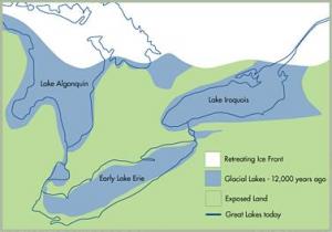
Glacial Great Lakes Map of South Western Ontario
Early Settlement History: Trading, Exploring, and Living
People have been living in the Great Lakes region for thousands of years. Lake Ontario, in particular, has been an important source of fish, as well as being a central point for transportation. Small groups of hunter-gatherers used the shore as a part of a major canoe route that extended laterally along the major river systems.
The earliest physical evidence of human hunters in the Great Lakes region dates to approximately 11,000 years ago, soon after the glacier retreated. They were mainly small bands of nomadic hunters who were pursuing animals such as caribou, mastodon and mammoth. Although evidence is limited, we know that multiple groups often camped near the elevated shorelines of the Great Lakes (See Fig. 8). Unfortunately, many of these settlements now lie underwater, some more than a kilometer into the lake, since the water levels of Lake Ontario have changed significantly since then. These invaluable sites are fragile and non-renewable. They have suffered staggering losses during the past two centuries due to deforestation, cultivation and urban growth. This has caused hundreds of sites to be irrevocably destroyed, leaving behind an incomplete record and many unanswered questions.
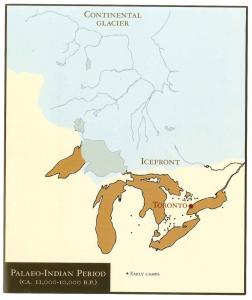
Early Paleolithic sites in the Great Lakes region
Lake Ontario As a Trading Route
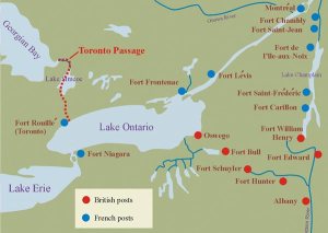
Lake Ontario was a center point for travelling. The north shoreline of Lake Ontario (aka Toronto) was a crucial junction for several important trade routes. The Lake has been vital means of transportation from the St. Lawrence to the interior of continent, as well as acting as a natural border between the north and the south. The rivers leading out of Lake Ontario (Credit, Rouge, Don Valley, and Humber) attracted people to the shores for fishing (mostly salmon) and linked inland communities to lakeside ones. The Rouge River and the Humber River in particular became important inland trading routes to the Holland River, Lake Simcoe, or the Georgian Bay. The waterways flowing from Lake Ontario acted as main thoroughfares, connecting many communities through a pattern of land trails. Portage points and river junctures were often important locations and became sites with popular trading posts, small towns and eventually forts.

Native drawn map on birchbark, showing parts of a portage route (1841)
Traders would canoe as far as possible, and then continue on foot along these routes. The Toronto Carrying Place Trail (also known as the Toronto passage) was the main route, following the Humber River Valley northward to the west branch of the Holland River. This route connected populations throughout the Great Lakes area. Many of these trails have since evolved into modern roads, such as Davenport.
The most striking shoreline feature on Lake Ontario itself was the southern peninsula (which later became Toronto Island). It helped create a sheltered harbor, and therefore a hospitable stopping place for those travelling by canoe along the hundreds of miles of coastlines along the north shore of Lake Ontario.
Encampments and temporary villages were situated along river valleys and lakeshore for over ten millennia. Although there is no written record of their lives, their legacy exists in oral histories and traditions passed down through many generations, as well as through traces of the settlements that exist today.
Lake Ontario as a Boundary
Lake Ontario acted as a boundary line between different groups of First Nation peoples. At the time of European contact, the resident peoples spoke several languages and dialects under three main linguistic groupings – Algonquian, Iroquoian, and Siouan. At the time, there were two main regions of the eastern woodlands inhabited by Iroquoian speaking peoples. Most lived in the northern region and were known as the Hurons, Neutrals, Wenros, Petuns, and Eries. The lands south and east of lake Ontario were the core homelands of five founding nations of the Haudenosaunee Confederacy, who later moved into the Toronto area during the 17th century.
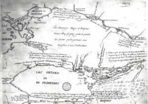
Map drawn in 1675, depicting early settlements on the northern shore of Lake Ontario. This is the first reference to Toronto on any map
Lake Ontario: Toronto Bay and Fort York
The Toronto Bay (or Toronto harbour) was an important location in terms defense during the late 18th century. The British authorities began to examine Toronto’s potential as a possible military settlement in the 1780s. By 1793, tensions were rising with the Americans and Simcoe was ordered to establish a new military post. Toronto was an excellent location from military perspective. It was removed from the immediate border region with the United States, deliberately distancing them from a nascent enemy. It was also enclosed within a sheltered harbor with only a single entrance, which protected them from sudden assault and could be easily defended against a naval attack. Currently, there are two channels into the harbor, at the east and west ends of the Toronto Islands. However, there was no eastern passage in 1793, because the “island” was actually a peninsula attached to the mainland. The harbor region was also strategic because it provided access to many inland locations. The roads could provide an alternative for transporting troops and supplies if the Americans took over the Lake, a looming threat as the war of 1812-14 approached.
Lieutenant Governor Simcoe ordered the construction of Fort York in 1793. He wanted to establish a naval base in Toronto in order to maintain control of Lake Ontario. At the same time, he also moved the capital from Niagara to Toronto, and renamed the area “York”, a decision that was not popular with the local inhabitants. The name was ultimately reconfirmed as Toronto when the city was incorporated in 1834.
In May of 1793, the Queen’s Rangers arrived and established the first military camp on the site of Fort York by the shore of Lake Ontario. Now, the Fort is actually hundreds of meters north of the shoreline due to efforts to fill the waterfront south of the fort between 1850s and 1920s but in 1793, the fort site was on the north shore of the harbour entrance. This brought a permanent military presence into the Lake Ontario region and effectively founded modern Toronto, as the army became the primary purchaser of goods and services in the area for many years and greatly impacted its economic development.
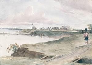
Fort York, August, 1839. Philip John Bainbridge (1817-1881)
Fort York was a focal point of action during war of 1812 (the Battle of York, April 1813). Ultimately, Simcoe failed to make York a strong, fortified naval base in Lake Ontario and Kingston eventually displaced it as the main headquarters.
The harbourfront was also a site of controversy and tragedy, including the murder of Wabakinine, a Mississauga chief who had signed the Toronto purchase, the major treaty that involved the transfer of land ownership of the Toronto region to the British. In August 1796, Charles McCuen, a soldier in the Queen’s Rangers, murdered Wabakinine and his wife on the waterfront at York. This initiated a potentially explosive situation as the Mississaugas, already frustrated by the failed promises of the Toronto Purchase, considered a counter attack, either on the capital itself or on nearby pioneer farms. The colony tried to appease the situation by bringing soldier to trial for murder but due to multiple misunderstandings, witnesses stayed away from the trial and the soldier was ultimately acquitted due to lack of evidence. In the end, an uprising did not occur at this time. Joseph Brant, an interpreter, guide and important diplomat, worked to preserve relations and a cautious peace was eventually achieved.
Lake Ontario: Changing Hands, Changing History
Lake Ontario has had many faces over the years. It has been a source of food, a meeting place and a travel location. It has been a source of conflict and a venue for creating friendships. It has seen battles, treaties, wars, bargains and betrayals. Lake Ontario has been an essential part of Toronto’s history and, for better or for worse, it has been integral to the formation of the city as we know it today.